Mapping Southbank
In the years from 1970 to 1974, people in South Melbourne became used to seeing men in the rear cab of a ute with a large camera taking photos of the houses and other buildings that made up the streetscape.
They were members of the Committee for Urban Action (CUA), a 1970s activist group that documented South Melbourne, regional cities and some other inner-city Melbourne streetscapes to combat destructive development and protect Victorian heritage.
Their extensive, 35mm photographic survey of South Melbourne streets, including Clarendon, Park, and Moray streets, is now held by the State Library Victoria. Their enormous collection of more than 2000 reels of 35mm film – more than 70,000 photographs in all – was donated to the Library in 1977 by Barbara Niven.
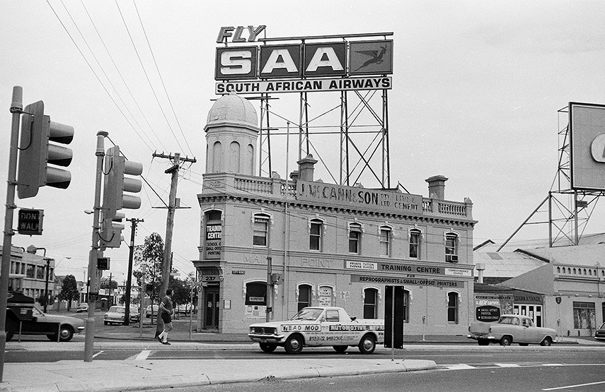
Much concern was starting to arise about the “piecemeal development” destroying Victorian and Edwardian architecture in South Melbourne, much of which is now Southbank. Members took comprehensive, strip-photographic surveys of streets, often detailing both sides of the road, to record building façades.
The CUA worked systematically, capturing photos street by street, and recording the locations of each set of photographs. This information was used to prepare the title attached to each photo as it’s uploaded to the SLV catalogue. In general, titles include the name of the road where the photo was taken, the name of the suburb or town, and the names of two intersecting roads that define the boundaries of the current road segment.
The pictorial record of South Melbourne area shows images of streets and buildings, including homes (single and double storey), laneways and street signs, as well as public buildings and small businesses such as milk bars, hairdressers, newsagents, garages, fruit shops, drapers and many pubs, generally on corners.
A typical range of photographs shows single storey houses, sometimes hidden by trees in the front yard, brick or iron/wire front fences and some double storey corner buildings. Some shops are included, such as a fish and chip shop adjoining a small house with a wire front fence.
Images also included architectural details such iron lacework, pediments and parapets, decorative orbs, wooden fretwork, bust mouldings, decorative chimneys and iron railing fences.
Some information is incorrect as some road names were wrongly documented, or because the names have changed over time, or the routes of some roads had changed – intersections no longer intersected, roads were closed, or new parks had emerged.
The images are considered an early “Google Street View” and act as a vital historical record used for heritage overlays. The aim was always to create some sort of map-based interface, that would allow users to click on a street and see any associated CUA photos.
As described, the title of each photograph generally includes four pieces of information: the road, suburb, intersecting roads, and side. The streetscapes have changed dramatically over the years, but we are left with an incredible array of images from 50 years ago.
Related Articles
Letting the fumes out at Southbank!
One of the most distinctive structures in Southbank sits in the small park along Grant St, next to the yellow Vault sculpture, itself a work of renown for the district. But it is not a dwelling – it’s a ventilation stack to release the fumes from the freeway that runs beneath.
Read More
Designing in Southbank
One of the many stylish blocks of apartments in Southbank is situated on Wells St. Unusually, the four-storey block in a garden setting runs through to Dodds St, at the rear of the Malthouse.
Read More
Bond Store, Southbank
In an area that contains numerous cafes, the Bond Store in Southbank, located at 1 Riverside Quay near to Eureka Tower and Freshwater Place, is one of the oldest coffee shops.
Read More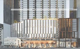
“Federation Square of the South”: council backs tower but pushes harder for Queensbridge Square
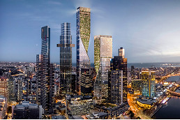
STH BNK site heads to market in major blow for Beulah’s stalled Southbank supertower
 Download the Latest Edition